


★★★★★ Difficult / North of Seligman
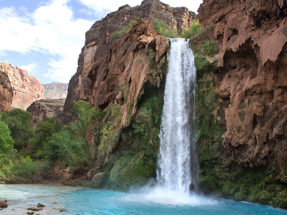
Turquoise blue water and a thundering 100′ waterfall make Havasu Falls one of Arizona’s most spectacular places. Winding through a remote desert canyon, the Havasu Falls Hiking Trail descends into a magical land – almost surreal in its beauty. Deep in the canyon, a treelined, icy blue creek, and roaring falls, flow between narrow 1,000′ canyon walls.
TRAILHEAD: Route 18, Hualapi reservation, north of seligman • DIFFICULTY: difficult • DISTANCE: 10 MILEs (20 miles RT) • APPROX. TIME: 6-8 HOURS, each way • ELEVATION GAIN: -3,350 FEET (-240 STORIES) • APPROX. CALORIES BURNED: 1,380-1580 each way • BEST TIME OF YEAR: feb.-nov. (hot in summer) • PETS: no • KID FRIENDLY: no • trailhead fACILITIES: yes, but no water • FEES: pre-purchased Havasupai tribe permits required! price based on length of stay.
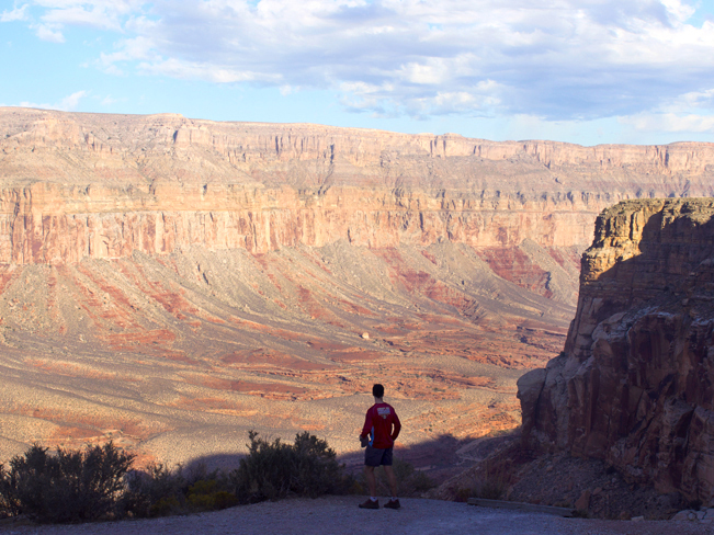 Standing at the Havasu trailhead, on Hualapai Hilltop, it’s hard to imagine the turquoise blue creek flowing 6.5 miles below. Stunning red canyons and dry, rocky desert fill the horizon. And not a hint of water can be seen. Please note that hiking Havasu Falls Trail is not allowed without a pre-purchased, Havasupi Falls permit! A ranger at the trailhead station confirms I.D.s, and checks them against a daily list of permit holders, before allowing hikers onto the trail.
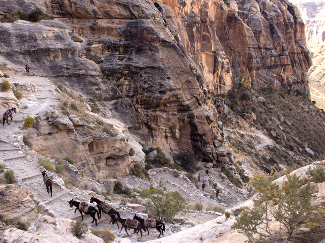 Stepping over the Haulapai Hilltop rim, the Havasu Falls Hiking Trail kicks off dramatically. A series of steep switchbacks descend 1,300′ to the Hualapai Canyon floor, on the first 1.75 miles of the hike. This is the most difficult leg. Not bad on the way down. But grueling on the way up. Post-early-morning, this section is fully exposed to the sun. The trail is shared with fast moving mule trains, carrying supplies in and out of the canyon. Be sure to move aside as you hear them approach. Their drivers are located far in back. And the mules are on auto-drive, paying little attention to hikers.
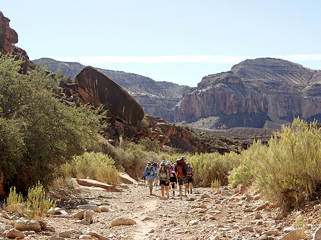 Once on the canyon floor, the Havasu Hiking Trail becomes mostly flat and easy. The next two miles follow a wide, gravely arroyo through an open section of Hualapai canyon. Expect full sun exposure, and gorgeous upward views.
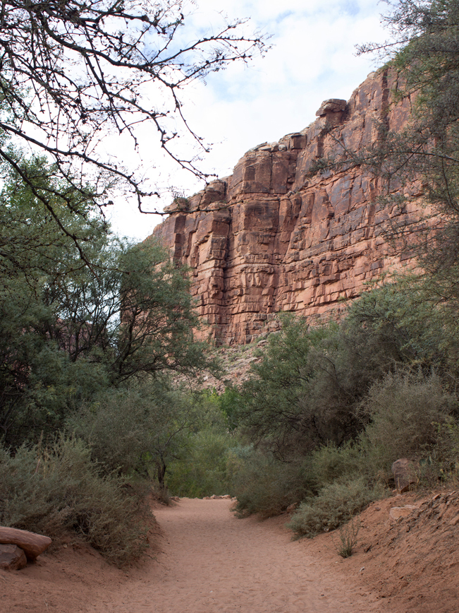
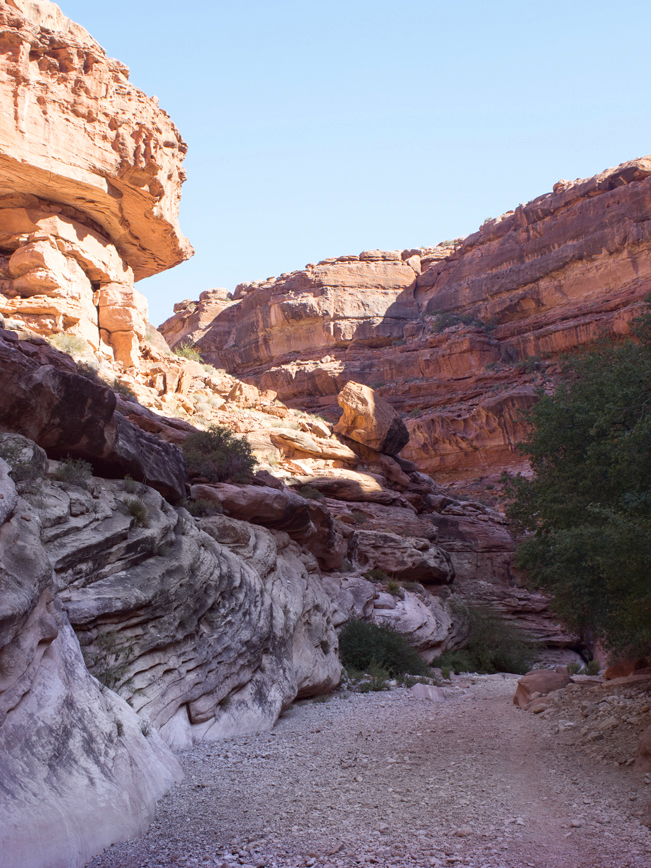 As the hike continues its gentle descent through Hualapai canyon, the walls gradually increase in height. Intermittent shade begins to grace the trail as the path winds from side to side. The trail passes wacky rock formations and pockmarked boulders, decorated with small rocks by passing hikers.
 At five miles, Hualapai Canyon narrows beneath dramatically soaring cliffs. This is my favorite part of the hike! Wonderfully deep shade cools this section. And it’s not surprising to step around shallow pools of water, left by past monsoons. The echos here are fantastic! Distant mules trains can be heard clomping up the trail, way before they can be seen.
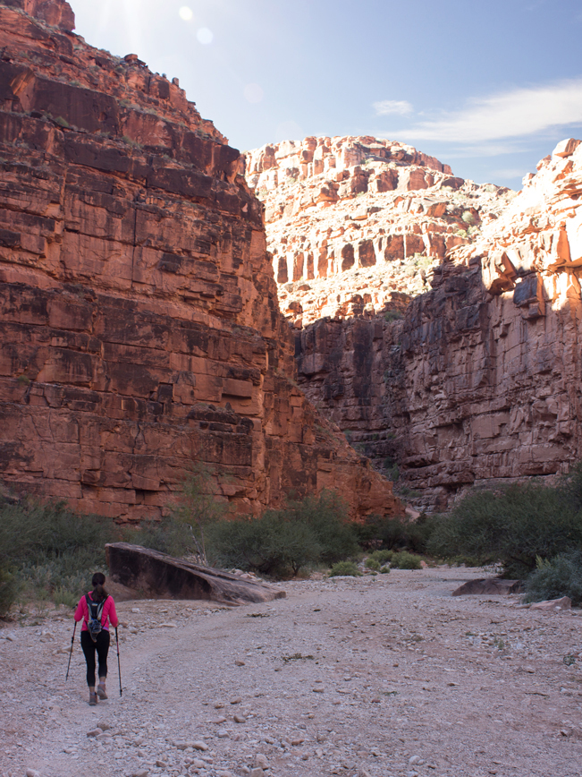
 After 6.5 miles, Hualupai Canyon comes to its end at the t-shaped confluence with Havasu Canyon. A rustic signpost points left to Supai Village, and the landscape suddenly transforms! The sound of rushing water is heard. And the trail converts to soft sand as it follows the shady banks of Havasu Creek.
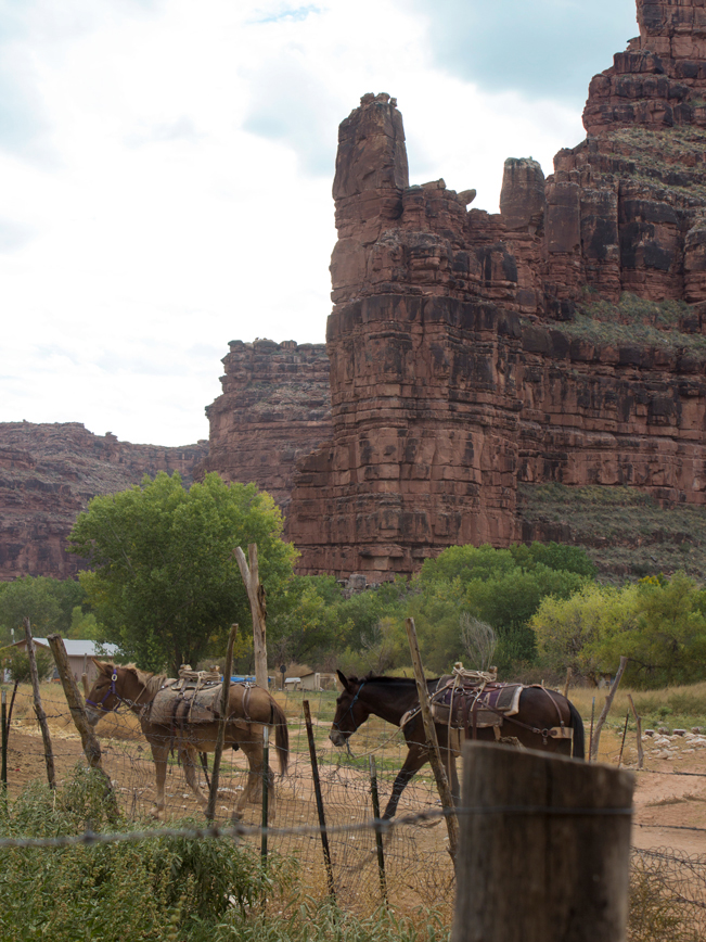 One mile further and the Havasu Hiking Trail enters remote Supai Village – the sacred home of the Havasupai tribe. Nestled between ancient Cottonwoods and sandy streets are the tourist office, Havasu Lodge, a small cafe, local store, heliport and a number of small private homes. Hikers must stop at the Tourist office to register and get their wrist and tent tags. A tribal representative periodically walks the campground and fall areas to check these items.
 After registering, hikers can continue on through the village. A signpost marks a righthand turn to the campground. This mildly descending, mile-long stretch is lined with deep, soft, beach-like sand.
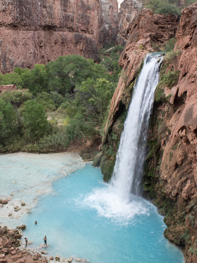 At around 9 miles, the Havasu Hiking Trail first passes 50-Foot Falls, and then Navajo Falls. These beautiful cascades are only partially visible from the trail, and definitely worth a visit! Finally, the trail reaches the top of 100′ Havasu Falls. The path steepens as it descends along the side of the fall to its base. The views are incredible. And after the long trek it’s great to have finally arrived!
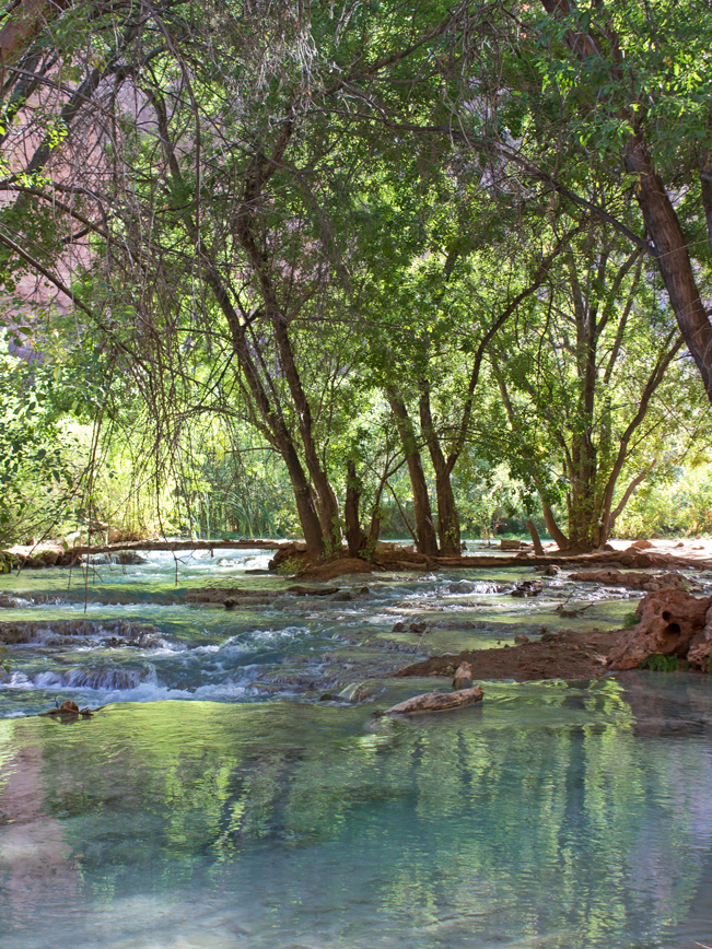
 From the base of Havasu Falls, the sandy trail continues along the creek. It passes an Indian Fry Bread stand, a ranger station, a mule train loading stable, and finally enters the campground. The narrow, mile-long Havasupai Falls Campground is gorgeous! Both sides are flanked by the soaring walls of Havasu Canyon. There are ample Shade trees. And the refreshing babble and cooling air from Havasu Creek, flowing through the center, make it insanely beautiful. Drop that backpack and set up camp in any of the lovely nooks and crannies. Camping is allowed anywhere between the fence, at the start of the campground, and the flat area just before the drop off of Mooney Falls.
Havasu Trail to Mooney & Beaver Falls & the Colorado River
The Havasu Falls Hiking Trail continues another 8 miles through the canyon. It makes a steep descent down Mooney Falls, then continues on to popular Beaver Falls. Both Havasu Creek and Hiking Trail end at the confluence of the Colorado River. Click here for details on Havasu Hiking Trail’s last 8-miles.
Total Nerdery
Havasupai roughly translates into people (pai) of the blue-green water (havasu). The stunning turquoise hue of Havasu Creek is the result of a high calcium content, which leaches into the 30,000 year old underground spring feeding the creek. A natural aquifer, deep within a limestone cavern at the mouth of Havasu Canyon, houses this spring,
Resources
Click here to download a trail map.
Directions: From the intersection of I-40 and Railroad Avenue, in Seligman, turn right / north onto Railroad Ave. At the end of Railroad Ave., turn left / west onto historic Route 66. Continue for 30 miles to Indian Route 18. Turn right / north onto Indian Route 18 and drive for 60 miles to its end at Haulapai Hilltop. Keep an eye out for free roaming cattle and horses along this gently rolling, fully paved road! At Haulapai Hilltop you’ll find ample parking, a ranger station, small heliport, vault toilets and the Havasu Falls Trailhead. All visitors to Havasu Falls are required to validate their pre-purchased permits and register with the ranger before starting the hike.
Getting a Permit for Havasu Falls
Click here for information on getting a permit for the Havasu Falls Hiking Trail and details on planning your trip.
Leave a Reply