


★★★★★ Difficult then Moderate / Supai
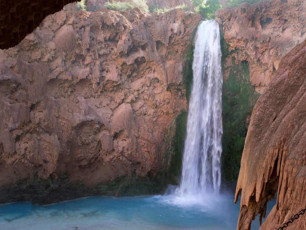
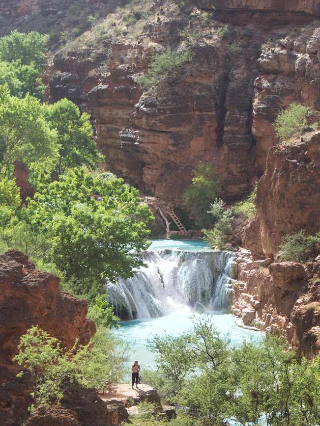
At just under 200 feet high, Mooney Falls is the most intensely beautiful cascade in all of Havasu Canyon! It thunders over a cliff one mile past the canyon’s namesake fall, and eleven miles from the Havasu Hiking Trailhead at Hualapai Hilltop. The Havasu Hiking Trail follows turquoise blue Havasu creek eight miles past Mooney Falls. As the trail winds down the canyon, it passes gorgeous Beaver Falls and endless mini-cascades. Finally Havasu Trail, Creek and Canyon come to their dramatic end at the mighty Colorado River.
TRAILHEAD: Havasupai Campround, supai • DIFFICULTY: difficult at start, then moderate • DISTANCE: 8 MILEs to Colorado River (16 miles RT) • APPROX. TIME: 8-12 HOURS RT • ELEVATION GAIN: -1,000 FEET (-71 STORIES) • APPROX. CALORIES BURNED: 2,080 – 2,400 RT • BEST TIME OF YEAR: feb.-nov. (hot in summer) • PETS: no • KID FRIENDLY: no • trailhead fACILITIES: yes, but no water • FEES: pre-purchased Havasupai tribe permits required! price based on length of stay.
NOTE: Getting to Mooney Falls, first requires traveling 11 miles through remote Havasu Canyon. Havasupai Falls Permits are required to enter the canyon and hike the Havasu Falls Trail. Click here for information on getting a Havasupai Falls Permit. Click here for details on the 11 mile hike to Mooney Falls.
Mooney Falls Hike
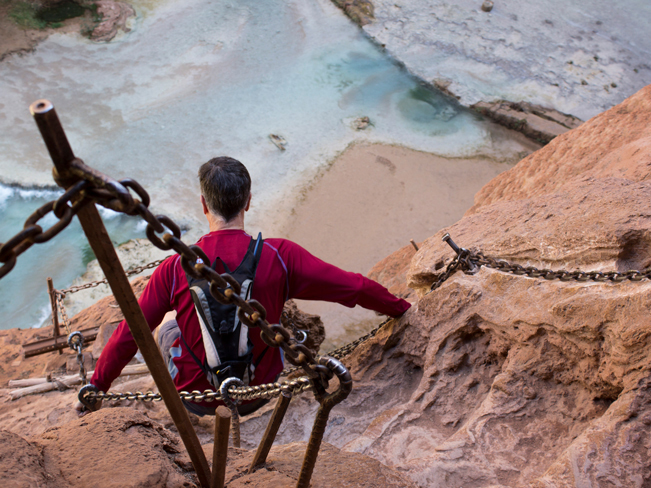
Eleven-miles down remote Havasu Canyon, Mooney Falls crashes 196 feet to the canyon floor. From the cliff top, at end of Havasupai Campground, the view over the fall is majorly impressive! Water-worn canyon walls appear to “drip” straight downwards to the sand and turquoise pools below. The short “hike” to the base of Mooney Falls is the steepest part of the entire Havasu Hiking Trail! Not recommended for people with vertigo.
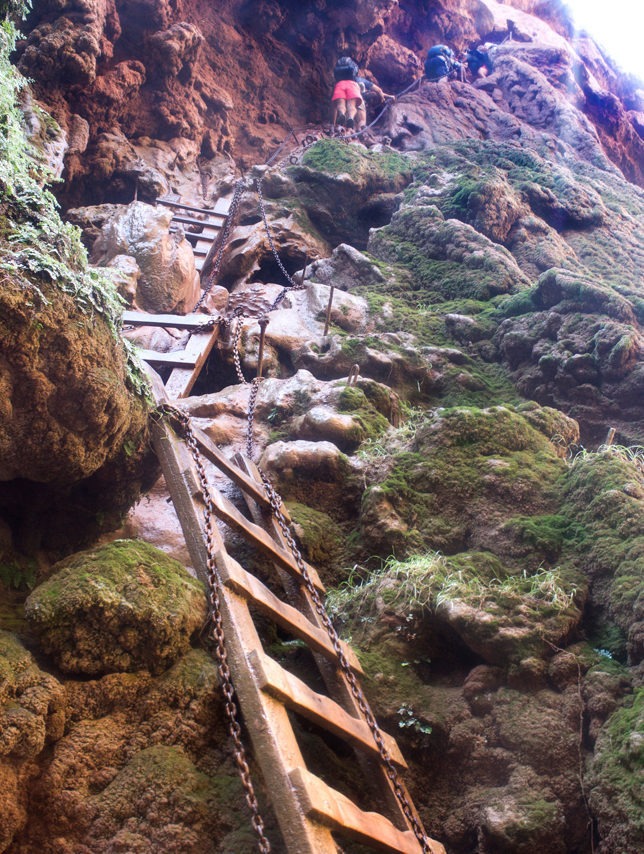 This hiking section is really an almost vertical, mist-soaked climb down the canyon wall. A series of short switchbacks, narrow tunnels, carved “steps” and wooden ladders lead the way. There are metal pegs and heavy chains to hang on to for balance. The trail can get a bit hairy when crowded with people going up and down. Head out in early morning for fewer people on the trail.
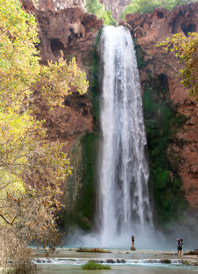 But OMG! The steep climb to the base of Mooney Falls is totally worth it! Standing below this powerful waterfall, in the middle of stunning Havasu canyon, is beyond words fantastic! A perfectly centered stone forms an Instagram-worthy photo platform. Fair warning that the spray from Mooney Falls drenches everyone at its base. No need to even get in the water.
Beaver Falls Hike
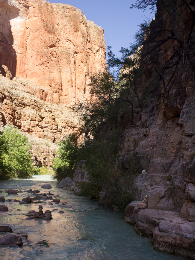
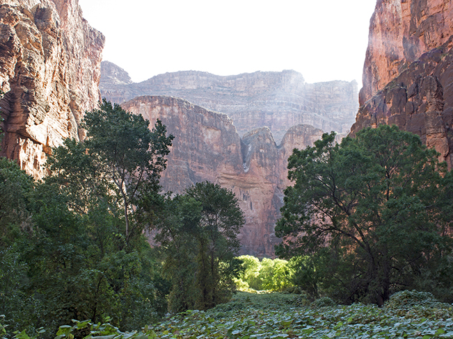 Passing Mooney Falls, the Havasu Hiking Trail continues down the canyon. It first descends a rocky hill. Then, for the next 3 miles, follows an easy, soft, sandy, vine lined, path. Here the lush green riverbank sits in stark contrast to the towering red and purple canyon walls. Look for Big-Horn Sheep in this area, grazing along the trail.
 As Havasu creek swerves through the canyon, it brushes up against either sandy, treelined expanses or steep canyon walls. To continue onwards, the Havasu Hiking Trail crosses the creek numerous times. Cairns mark most crossings. And simple wooden bridges have been laid in some spots. But wading is often the easiest way to get from side to side.
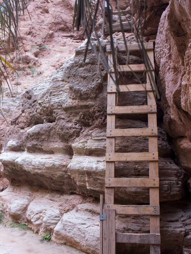 Three and a half miles past Mooney Falls a wooden ladder starts a modest climb up the side of the canyon. The ladder sits just behind a huge Palm. A bizarre plant to come across in the middle the Grand Canyon!
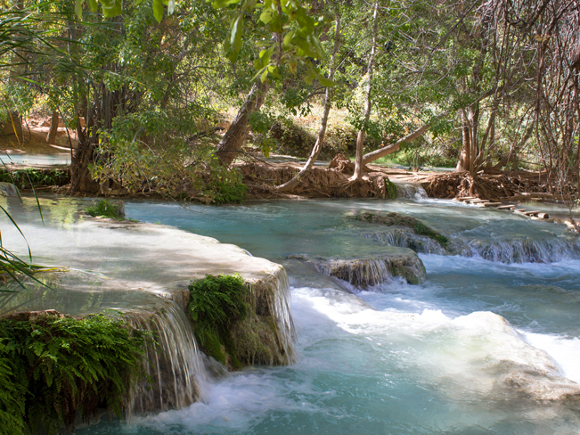
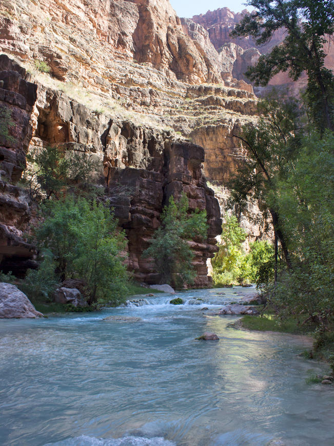
 The Havasu Hiking Trail ascends another half mile, offering luscious views over the creek. About 4 miles past Mooney Falls, gorgeous Beaver Falls comes into view. A short side trail leads to its base. Multiple cascades and stone platforms make Beaver Falls a fantastic place to hang out and play.
Colorado River Hike
 Passing Beaver Falls, the Havasu Hiking Trail continues its journey towards the Colorado River. A small sign, just past the Beaver Falls side trail, marks the crossover into Grand Canyon National Park. The path continues one mile, along the side of the canyon, high above the creek. It then makes a steep, narrow descent back down to the water. From the cliff base, cairns mark the way through the creek to the trail’s sandy continuation around a bend.
 For the next 2 miles the Havasu Hiking Trail is sandy and mostly flat. It crosses the creek a few more times, where the water curves around tall stone cliffs. The canyon is narrow and dramatically beautiful. Sunlight filters in from high above.
Just a few hundred yards from the Colorado River, the little bit of land alongside the creek completely disappears. In its place, steep walls line the water’s edges. Hikers can wade a short distance through the creek. But take care, as the current gets strong and dangerous as it approaches the Colorado. To see the confluence, climb up the ridge on the left side of the canyon and follow the trail to the River. Rafting tours often anchor here. It’s incredible to witness Havasu’s turquoise blue water blending with the teal water of the Colorado River, in the middle of the Grand Canyon. To return to Mooney Falls and the Havasupai Campground, turn around and make the same stunning 8-mile hike along Havasu Creek.
Total Nerdery
Mooney Falls is named after prospector Daniel Mooney’s sad story. He died in1882 trying to descend the fall. His repelling rope was cut in two by the canyon’s rough stone walls. And he fell to his death. In 1883 Mooney’s team returned. They blasting out existing caves, created tunnels, and pounded spikes and chains into the rocks to reach the base. The current trail is the result of their efforts*.
*source: GrandCanyonSecrets.com
Resources
Click here to download a trail map
Directions: From the intersection of I-40 and Railroad Avenue, in Seligman, turn right / north onto Railroad Ave. At the end of Railroad Ave., turn left / west onto historic Route 66. Continue for 30 miles to Indian Route 18. Turn right / north onto Indian Route 18 and drive for 60 miles to its end at Haulapai Hilltop. Keep an eye out for free roaming cattle and horses along this gently rolling, fully paved road! Haulapai Hilltop has ample parking, a ranger station, small heliport, vault toilets and the Havasu Falls Trailhead. All visitors to Havasu Falls are required to validate their pre-purchased permits and register with the ranger before entering the Havasu Canyon. The top of Mooney Falls is 11-miles down the canyon, on the Havasu Hiking Trail.
Leave a Reply